Page 1 of 2
understanding geo table
Posted: Wed Jun 01, 2022 6:50 am
by ajith
respected sir,
i have been working with 3 axis robot controlled by kmotion driven by stepper motor. I have been experiencing change in motor position of all axis when i move only one axis using gcode but other remaining two axis have been rotating very slightly.how i need to control all three axis individually.note that the gcode i used only has the command to move one axis only.
so I deleted the geo file declared already and again run the same gcode and it works fine. i have no idea what is the problem in this.
regarding,
M.Ajith Arwinth;
Re: understanding geo table
Posted: Wed Jun 01, 2022 4:34 pm
by TomKerekes
A geo correction table is used to make corrections when the xyz axes are not perfectly straight and orthogonal. So yes with a geo correction table moving one axis in CAD space is likely to have multiple motors move. I don't understand the problem. If you do not want geocorrections to be made then don't use a geo correction table.
Re: understanding geo table
Posted: Thu Jun 02, 2022 12:46 pm
by ajith
Respected Sir,
Today i have tried to create a geotable file as per your guidance and faced some following problem,
These are file i had assigned . measurement.txt file used as geotable file.
After assigning the file and press ok i got a popup window of above message.the file i used to assign for geotable file consists of three lines
5,5
1,1
0,0
after ignoring the message, i jogged my y axis to 100 and pressed measure button
After pressing the measure button, the values written in the geotable file and the jogged value is not same.
Re: understanding geo table
Posted: Thu Jun 02, 2022 4:52 pm
by TomKerekes
The Geo Correction file units are inches.
Re: understanding geo table
Posted: Fri Jun 03, 2022 3:55 am
by ajith
Respected sir,
Is there a way to change its units. and may I know the reason for the popup messsage
Re: understanding geo table
Posted: Fri Jun 03, 2022 4:02 pm
by TomKerekes
Invalid Geo Correction File format. it should be 3 lines of header and then Rows x Cols lines of 5 values per line.
Re: understanding geo table
Posted: Wed Jun 08, 2022 6:04 am
by ajith
Respected sir,
Is there a way to change its units.
Invalid Geo Correction File format. it should be 3 lines of header and then Rows x Cols lines of 5 values per line.
as per my understanding after reading the kflop manual, i think that 1st line specifies no of rows and colums and 2nd line indicates delta X and delta Y.
third line indicates table xy offset.and the remaining lines are row , column,x,y,z table entries.
i dont know about the header u are saying in the geo file.
Re: understanding geo table
Posted: Wed Jun 08, 2022 3:50 pm
by TomKerekes
Is there a way to change its units.
no
as per my understanding after reading the kflop manual, i think that 1st line specifies no of rows and colums and 2nd line indicates delta X and delta Y.
third line indicates table xy offset.and the remaining lines are row , column,x,y,z table entries.
correct
i dont know about the header u are saying in the geo file.
The first 3 lines
Re: understanding geo table
Posted: Tue Jun 14, 2022 4:44 am
by ajith
Respected Sir,
Are you suggesting to create a txt file and type the first three lines which include no of rows and columns and the second line defines the delta X and delta Y and the third line indicates the x and Y offset. then after saving the text file i need to define that file path in toolsetup screen - too/setup files - geo file.this is the image containing the file i have created for geotable.
this is image of window popuped after defining the path of the file i have created in geo file .
Re: understanding geo table
Posted: Tue Jun 14, 2022 5:52 pm
by TomKerekes
Are you suggesting to create a txt file and type the first three lines which include no of rows and columns and the second line defines the delta X and delta Y and the third line indicates the x and Y offset. then after saving the text file i need to define that file path in toolsetup screen - too/setup files - geo file.
Partially correct. The txt file must be called measurements.txt in the Data folder. As indicated by the tool tip on the measure button.
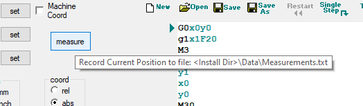
- measure.png (6.76 KiB) Viewed 6921 times
And you do not want to specify the file in the Tool Setup screen until after it is valid and fully populated with data.
this is image of window popuped after defining the path of the file i have created in geo file .
That is because the file is basically empty and invalid.